Saturday, 1 September 2018

MRS. HESLOP, I PRESUME?

Ready for the next adventure
Another bright and sunny day, we continued south into Prince Regent Inlet and to the eastern entrance to Bellot Strait.  

The historic site of Fort Ross located on the southern end of Somerset Island was home to a former Hudson’s Bay Company fur trading outpost, as well as archaeological sites dating back over a thousand years.
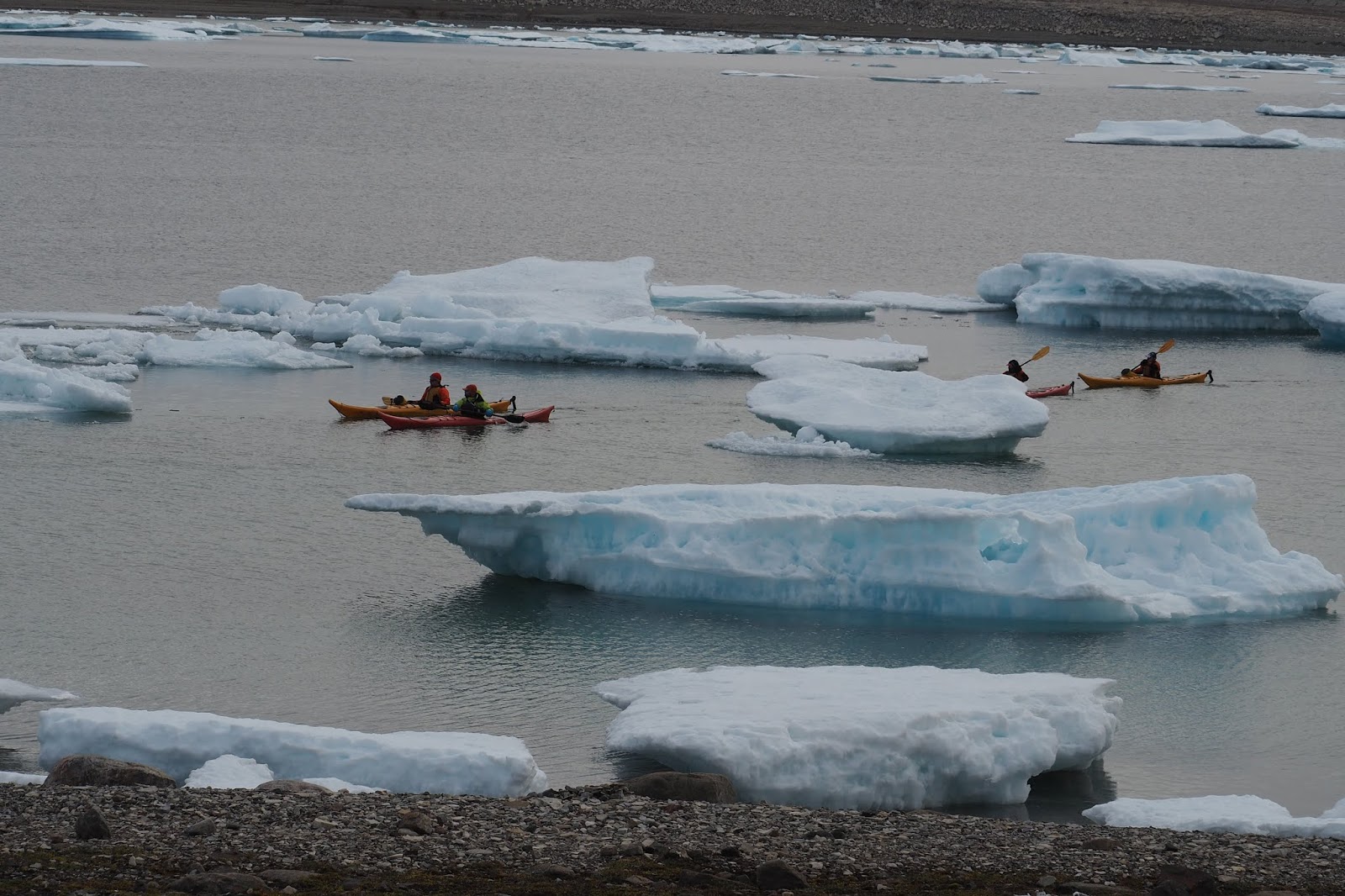
Kayakers already in the water
Zodiacs in the water we were ready having performed our daily ritual of layering up from merino base layers to mid polar fleece layers to waterproof outer wear, topped off with double socks, double gloves, boots, hats and the all important personal flotation device.  

Meantime our stalwart companions who had signed up for the kayak program set off to explore the coastline.

Obstacle course for the zodiacs
Abandoned HBC outpost
Safely aboard, we edged our way from ship to shore through gaps in the ice, many chunks of which were grounded and sitting high in the water, taking on the appearance of oversized piecrusts.  
Clambering on the rocky shore, now equipped with sturdy walking poles, we climbed up the beach to the abandoned HBC buildings, one the former trading post, the other the living quarters of the station manager and his wife, Mr. and Mrs. Heslop.

A climb around the perimeter of the buildings revealed the multi-coloured lichen growing on the reddish rocks.  Occasionally there would be the odd rock strewn around that appeared uncharacteristic to the landscape.  Known as "erratics" these particular rocks had been deposited by the glaciers.

While the Heslops' living quarters looked like they had been reasonably cozy at one time, through the broken windows the rusty frames of easy chairs and peeling wallpaper told the story. A dilapidated coffee pot sat on the pot bellied stove along with two rusting metal mugs, somehow frozen in time.

It must have been a solitary life and its hard to imagine being assigned to this wilderness and finding that after almost three years the much anticipated supply ship was still unable to reach Fort Ross because of packed ice.

After an emergency meeting at HBC headquarters in Winnipeg in 1943 it was decided to evacuate the outpost by air.  This had never been attempted in this part of the Arctic before and finding no suitable aircraft for the mission in Canada, HBC contacted the U.S. military.

The result was the first parachute jump in the Canadian Arctic.  Air Force Captain Stamwell-Fletcher jumped out of the aircraft, the aim being to find a suitable landing site.  This was his first parachute jump after only one day of instruction. 

Apparently he did it in style, somersaulting in the air and upon landing bowing as he greeted the station manager’s wife with “Mrs Heslop, I presume”. A potential runway was found on the surface of a frozen lake ten miles away from the outpost and the site was hastily evacuated.  The Heslops were told to leave everything behind, hence the interesting array of decaying items strewn around their dwelling, victims of the howling winds and relentless weather.

A wild and uninviting landscape with a bit of a romantic back story.

IF ONLY FRANKLIN HAD HAD THE BENEFIT OF ICE CHARTS

North American continent to the left, Arctic Archipelago to the right
Seven miles south of Fort Ross lies the Bellot Strait which links Prince Regent Inlet to Peel Sound and the Franklin Strait.  

Bellot Strait is remarkable because it divides the top of continental North America and the Arctic Archipelago.

A late afternoon zodiac cruise took us into the Strait between the ice flows and a strong incoming tide. A bearded seal popped his head up between the ice while we admired the red beaches formed 
from two billion year old rock formations.

Ice flanked the beaches. The floating masses seemed like silent sentinels as we motored between them. All body parts inside the zodiac!  Ice does not bend.


High up on the cliffside a polar bear sauntered along, occasionally looking down on a lone Muskox, his hairy body and curled horns giving the appearance of shaggy highland cattle.  We trained our binoculars on the goings on for as long as we could.

Polar Bear
Muskox
The polar bear disappeared and we hoped he wasn’t stalking the Muskox.

We would never know as it was time to return to Vavilov. 

It was frigid on the water and Becky was a welcome sight on the gangway with mugs of hot chocolate with a shot of Baileys.  A perfect end to another great day.

Tonight’s ice report will determine our ongoing itinerary and disembarkation point.  Unable to continue on to Victoria Strait and Prince William Island because of packed sea ice a Plan B had us returning north to Resolute which turned out to be inaccessible for the same reasons.  

A Plan C was adopted – south to Pelly Bay and the Inuit community of Kugaaruk which just happens to have extended its gravel runway.  A good possibility for our charter flight back to Edmonton via Yellowknife.  Nothing like expedition cruising.


Around here, ice is king as Sir John Franklin would tell you, if he could. Victory Point, Prince William Island and Victoria Island will have to wait another day.

EPILOGUE - EXPEDITION TRAVEL IN THE NORTH

The daily ice chart.  Red areas are "no go".
Fast moving swimmer
As our itinerary was adjusted to sail around heavy sea ice we were in for more polar bear encounters.

Ursus Maritimus is designed for the cold, built for predation and instilled with incredible patience. The polar bear is a strong swimmer, moving fast in the water while travelling long distances.

Our first nautical sighting was an adult bear swimming so rapidly he sent out a chevron-like wake as he moved between the sea ice.  

A further sighting involved a bear at much closer range.  He looked over at us sitting transfixed in the zodiac and didn’t look particularly impressed, changing his direction sharply away from us.

Continuing south we explored Maniiturjuaq Islands. Zodiac cruising produced more bird sightings and another polar bear in the water.  Several zodiac propellers met with submerged rocks and in retrospect the Inukshuks on shore could have been a warning sign to beware of shallow waters.  The islands’ Inuktitut name translates into “Rough Islands”. Very appropriate

As we headed south to Kugaaruk the ocean was now clear of sea ice, so no more bear encounters.  However there were bearded seals, walrus and even a brief narwhal sighting. Approaching Pelly Bay, a place where few vessels have been before, the hamlet of Kugaaruk came into view.  With a population of around 900, 97% of the inhabitants are Inuit.  This community, and many others, is supplied annually in an operation called “Sealift”.  Fortunately for us the gravel runway at Kugaaruk’s airstrip would be suitable to take us south. 

Our voyage of discovery!
Kugaaruk holds the record for the coldest wind chill ever recorded in Canada.  A new record was set in February 2018, -51.9 degrees centigrade. Despite the arctic freeze the warmth of the people was positively tropical.  We were warmly welcomed by the community as we awaited our charter to Edmonton. 

Unfortunately it wasn’t to be.  Weather conditions had prevented the incoming flight from arriving so it was back to Vavilov for another night on board.

Zodiacs from Vavilov speed towards Ioffe to begin the evacuation
This put everyone’s onward travel plans into chaos and staff on board worked hard to do whatever they could for us as well as assisting the delayed incoming passengers stranded in Yellowknife. While unsettling, all this paled when we realized what had been going on behind the scenes.  Vavilov had been summoned to assist another vessel that was in distress.  Coastguard vessels were en route but Vavilov was closer, just twelve hours away.  

Imagine everyone’s shock to learn that the stricken vessel was none other than Vavilov’s sister ship, Ioffe.  She had struck a submerged rock, apparently uncharted, and was taking on water which thankfully was contained in the hull’s compartment system.

Some members of the wonderful expedition team
Our job was to evacuate the passengers while Coastguard officials assessed the damage.  We reached Ioffe at five the next morning and the evacuation procedure was underway immediately.  

It went smoothly and efficiently but must have been shocking for the folks on board as they waited through the night with lifejackets in hand for us to arrive. Our little Vavilov was pretty crowded as we returned to Kugaaruk.  

The plan was to have Vavilov’s passengers fly out late that evening while Ioffe passengers, whose journey had now been officially abandoned, would leave the following day on aircraft bringing the incoming passengers delayed in Yellowknife.  A logistical nightmare.

Deja vu, we prepared to leave Vavilov for a second time.  As our zodiacs reached the pebble beach we were greeted by an armada of pickup trucks parked on the beach marshaled by local RCMP officers.  "Slide to the front of the zodiac and mind the Narwhal head as you step ashore ...."  I am not making this up.

Kugaaruk International Airport .... that should read "Airstrip"
It was a totally Canadian experience as we were helped ashore for what was supposed to be a dry landing even though we were well into the water.  Arms were about us from all sides as we stepped down onto dry land.  Good humoured police officers directed us to the waiting vehicles.  While caked in mud and dust it didn’t matter.  We piled in for the drive up to the community centre for a brief wait and then on to the airstrip.

Our driver said the RCMP had asked townsfolk to offer up their vehicles for the exercise, a sort of Arctic Uber which would likely be repeating itself the following day for the other passengers.  The gentleman who drove us said the town wanted to do anything it could to help out.

It left us with a warm feeling for our northern neighbours and the challenging lives they lead in this harsh environment as well as an appreciation for the value that is placed on the land and the water.  It also made us think about the reason we had ventured north in the first place – Franklin.

It had turned out to be not solely about the Franklin expedition, all the many other missions of exploration to find a northern trade route and the efforts to find out what had happened to Franklin, his vessels and crew.  It was so much more. We hadn't counted on our wonderful experiences with the first peoples of the north.  

Despite this, the Franklin story continues to evoke all sorts of emotions and made us think about Canada’s second National Anthem “Northwest Passage” by Stan Rogers.  The chorus summed things up perfectly –

“Ah for just one time I would take the Northwest Passage
To find the hand of Franklin reaching for the Beaufort Sea
Tracing one warm line through a land so wild and savage
And make a North West Passage to the Sea”.

During those daily ice briefings on board Vavilov, Franklin must have been there in spirit, muttering "I could have told you so".

Sunday, 10 June 2018

UNDER THE VOLCANO

Pilot arrives to guide us into port
The Vestmannaeyjar archipelago (the Westman Islands) lies off the south west coast of mainland Iceland.  Heimaey, the largest island in the group, is the only inhabited one.  Originally settled by escaped Irish slaves in 900 AD the islands suffered through hardships and piracy during its long history.  
A long way to go for milk!

In spite of it all, Heimaey evolved into an important part of the Icelandic fishing industry because of its strategic harbour and proximity to the fishing grounds.  

Ocean Diamond’s sail into Heimaey was nothing short of amazing.  A protected harbour set amongst steep volcanic outcrops, the secluded port was not immediately visible from the sea.  As we manoeuvred around each dramatic rocky protrusion, the town and its harbour eventually came into view. For the ship’s crew it was a fine display of seamanship navigating to the dock. 

It was the events of January 1973 that have created a new landscape in this part of the world.  Without any warning a large fissure angrily split the earth open disgorging molten lava.  The town’s 5,000 inhabitants were evacuated but two days later a large cinder cone erupted from the fissure.  While close to 800 homes were destroyed Heimaey had gained a new volcano that was subsequently named Eldfell (Fire Mountain).  The eruption lasted over five months.

Lava Flow frozen in time
During the eruption efforts were made to slow the advance of the lava as it threatened to engulf the town and its harbour.  

A pumping ship arrived spraying 100 gallons of seawater per second.  With the help of more powerful pumps over six million tons of seawater was pumped onto the lava in efforts to halt the encroaching lava flow.  

The harbour was saved as well as part of the town but almost 50 years later the drama of that time is front and centre.  Had that eruption closed off the harbour it would have brought disaster to the fishing industry, the main activity of the town.

Volcanic landscape popular with hikers
Reminiscent of a lunar landscape the lava flow from all those years ago looks harmless now with moss and lichen making the black and red rock home.  There are visible remnants of homes engulfed by the lava flow, now replaced by neatly kept rows of homes lining the quiet streets. The town’s museum does an excellent job of showcasing the eruption that caused one of Iceland's worst natural disasters. Eldheimar, is a museum of remembrance with exhibits that focuses on the impacts of the eruptions.

Visiting the weather research facility high on the island, the view of the volcanic landscape and an 18 hole golf course set in part of a crater was a pretty dramatic setting.  Icelanders love their golf!

Pristine greens - spot the elephant trunks in the rock face
We were blessed by an uneventful sail out of the Westman Islands and enjoyed calm seas for the last leg of the journey back to Reykjavik, completing our circumnavigation of Iceland.  

Despite the previous day's stellar display of seamanship, our arrival into the port of Reykjavik the next morning went awry.  The starboard side of the ship scraped hard against the breakwater.  Hopefully just a paint job.  

But what grist for Tatyana’s mill as she prepares for her next group of passengers!  

That’s the thing about Iceland, land of ice and fire.  It’s full of surprises on all sorts of levels.

ALL ALONE IN ICELAND

Taking in the view before descending into the next valley
Arriving in the port of Djupivogur on the south eastern coast of Iceland reinforced the solitude of the communities in this part of the country.

Another attractive coastal town but it was what lay beyond that would be the focus of today's excursion.

Setting off in our “super jeep” we travelled the coast road along Highway 1, the narrow two lane highway that encircles Iceland.
Angelica Canyon


Soon we were off road travelling along a narrow track. The scenery, one for the picture books.  

Reindeer Jawbone
Our first stop was a deep canyon known as Angelica its rock formations varied and colourful.

Crystal clear spring water flowed rapidly through the canyon, its taste pure, its temperature frigid despite the sunny day. The rock formations are made up of calcium, iron and copper tones making it an astonishingly colourful landscape.  

Glacial river bed in the valley
Magma from an ancient eruption had forced itself through some of the rock face giving the cliff a look of an egg salad sandwich.

Driving effortlessly over small boulders and rushing streams we made our way to a narrow winding track that traversed the mountainside.  While washed out in places our vehicle made little work of navigating, the views below and above breathtaking.  

Glacial rivers, the bright green new growth on budding birch trees and the backdrop of mountainsides coloured sage, cranberry, teal and grey were literally a kaleidoscope of colour.


Young reindeer
Our next stop was Arctic Fox Nest Canyon and its cascading waterfall.  We sat on the rocks to eat our picnic lunch while taking in the view.

Reindeer were introduced to Iceland from Norway in the 18th Century because of their adaptability to harsh environments but they roam wild, Icelanders preferring to tend their sheep instead.
Hidden waterfalls

A group of young males caught our attention, their antlers covered in black hair this early in the season.

As we returned along the winding trail through the mountains to the highway there was another surprise in store when we were introduced to a hidden series of waterfalls. 

Walking over the lichen covered boulders we followed a bubbling stream as it turned a corner where the waterfall complex came into view.

The main waterfall thunders down from the glacier in front of an open cave presenting an enticing opportunity to walk behind it. 

Two smaller waterfalls flank the horseshoe shaped outcrop while steep snow covered mountains overlook this fusion of bubbling water as it crashes its way to the sea through the boulder clad stream.

The power of nature had struck again today, very forcefully.

PUFFIN PARADISE

Waterfalls pour down in Seydisfjordur
The small town of Seydisfjordur in East Iceland lies at the head of a deep fjord with jagged snow capped peaks looking down somewhat menacingly on the town.  A familiar theme on our travels but Icelanders tend to take these things in stride.

Downtown Seydisfjordur
As with other small towns we’d visited, homes are brightly painted and well cared for.  Activity centres around fish processing, the acrid air around town palpable.  

Tourism is on the increase but this part of Iceland is remote and during the cold, dark winter months it must test the will with roads to the outside world often impassable.  A Danish ferry comes in weekly on its Denmark - Faroe Islands - Iceland run, but the atmosphere in this community defines isolation.

A four wheel drive contraption – a truck come bus – took us along a narrow gravel road that crossed river beds bubbling with icy water streaming down from the melting snow high above.  Passing Viking era excavations and deserted farmhouses, the long cultural history this area has seen was underscored.

Fancy digs for the eider duck
At Skalanes Farmhouse we had a close up view of nesting eider duck, their valuable down harvested from the nest lining.  Some ducks are so accustomed to their environment they allow the farmer to pick them up and replace them carefully back in the nest after part of the down lining has been removed, the farmer having created a series of smart looking nesting boxes along the shoreline. 

The sky was alive with action.  This particular area, Skalanes Nature Reserve, is home to fifty different bird species during summer and we enjoyed the sights and sounds of some of them.  The territorial Arctic Tern swoops down in irritation when anything invades its patch, amazing how a relatively small bird could look so threatening. 

Gulls and Puffin nesting on the cliff face
Busted!
The colourful puffin with its orange feet and facial markings and tiny black wings that seem far too small for its body felt a lot less intimidating.

Little darlings and so photogenic.

All manner of gull nest on the unwelcoming cliff sides that sweep down to the ocean, their choice to nest well placed as young birds often fall victim to marauding arctic fox and mink.  

There is a bounty on these predators and the farmhouse had an impressive display of skins adorning the walls. 


While the landscape was wild and unwelcoming to us, it positively teemed with life.  The howling wind merely providing the means for all manner of bird life to survey and thrive in their unique environment.

Saturday, 9 June 2018

TRAPPED IN SIGLO

Siglo's Hotel
The story of Iceland's herring industry tells a familiar tale of boom and bust.

This modern day saga is thoughtfully told in a series of museums in Siglufordur’s town centre in North Iceland.  A re-enactment of the lives led by the "herring girls" fun to watch.

The town’s setting is picturesque with restored, colourful buildings nestled along the waterfront.  

Sweeping snow capped mountains rise all around from the valley floor.  Tell tale signs of avalanche danger are everywhere with an intricate series of break wall fencing embroidering the surrounding mountainsides.

Part of the museum complex
In the herring boom years an atmosphere much like the gold rush existed.  Siglo, as it’s called by the locals was the place to be.  Times were good.  And then the herring stopping coming.  The resource had been overfished.

Bad times followed with townspeople thrown out of work when the fish processing plants closed down.
"The Herring Girls"

Despite its erratic history, Siglo has made an impressive resurgence. Many people who had left in search of work elsewhere have returned and the town has been transformed.  The herring museum complex for one. 

An old dilapidated building has been converted into a successful hotel as hikers and nature enthusiastic discover this beautiful place.  

The Icelandic TV series “Trapped” was also filmed here and in Seydisfjordur, a later port of call.

Our day in Siglo was a revelation of sorts. We had been encouraged by the fact that changing course after bad times can turn out for the better in the end.